The user organisation
The research group in Landscape Analysis & Management of the Department of Geography of the University of Girona (Udg; Spain) is a leading research group in basic and applied research in regional planning and management. Its core research activities include management of coastal areas, ecological connectivity, landscape policy design, GIS-based modelling and remote sensing.
Challenges faced by the user
The project Blue-Paths - Addressing Sustainability Transition Pathways in the Blue Economy is funded by the EC (GA: 101062188 ) under the HORIZON – Marie Skłodowska-Curie Actions 2021 of the Horizon EU program. The fellowship is carried out at the University of Girona (Spain, Department of Geography). Blue-Paths aims to foster sustainable use of the marine socio-ecological systems (SES) through the development of an innovative Sustainable Transition Framework (STF), that will investigate the pathways of pervasive ocean technologies (OTs) transformations in the most important sectors of the Blue Economy e.g. Ocean Renewable Energy (ORE) Systems, coastal tourism, shipping, nature protection. The study area is the Spanish sea space.
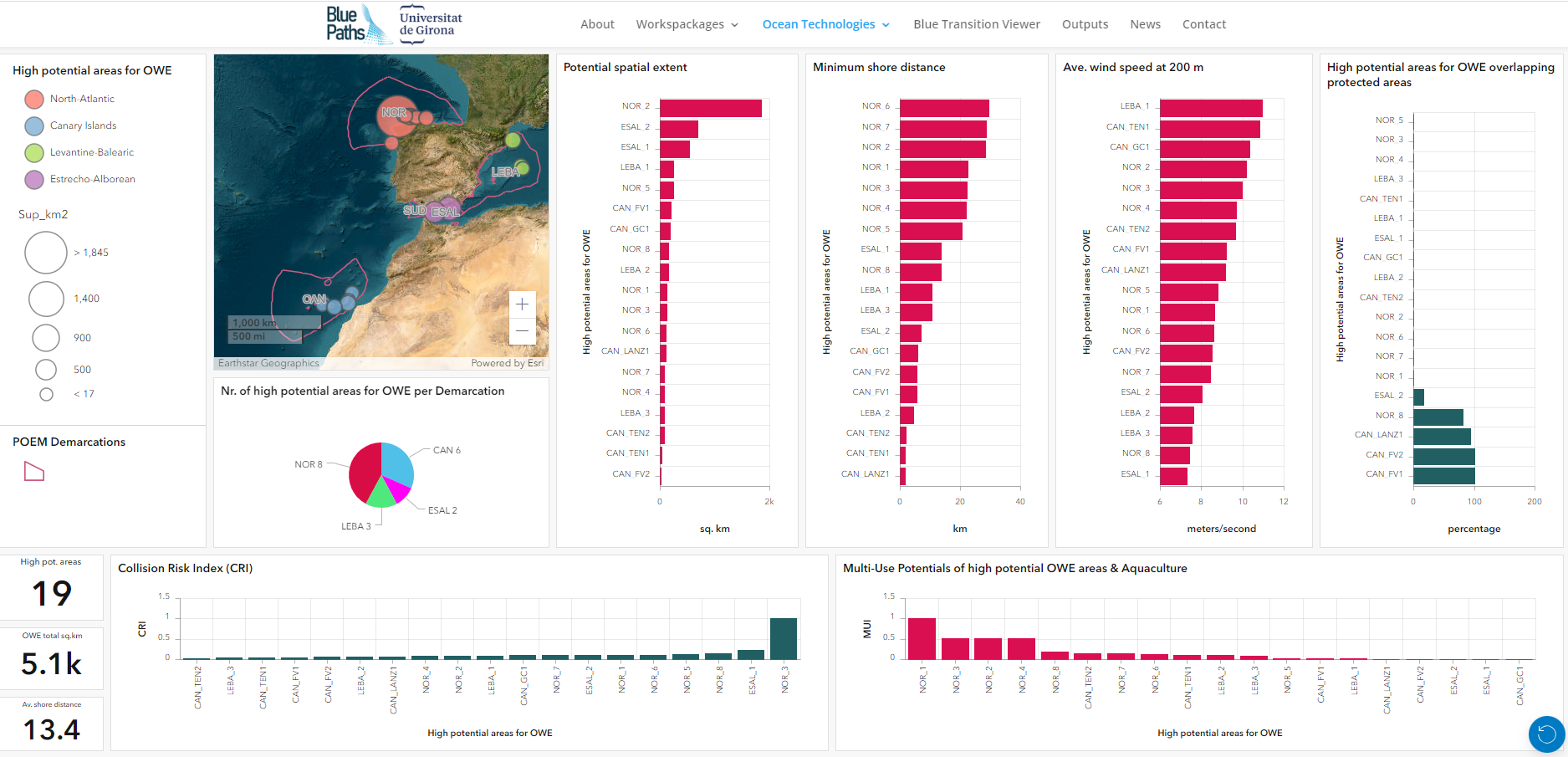
In Blue-Paths, EMODnet datasets were used for the development of a dashboard demonstrator . The dashboard has dissemination purposes to highlight the spatial conditions and interaction of the high potential areas for offshore wind energy with other human activities.
EMODnet services used
The project used various datasets from EMODnet Bathymetry and EMODnet Human Activities for the dashboard design and the development of indicators. These are as follows:
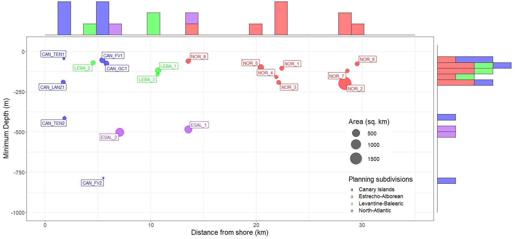
- EMODnet Human Activities, high-potential areas of Offshore Wind Energy: [presence/absence] 19 high-potential areas for offshore Wind Energy in Spain according to the Spanish Maritime Spatial Plan (Real Decreto 150/2023; EMODnet Human Activities, 2023).
- EMODnet Bathymetry, mean depth: [meters] This dataset was used to measure the mean depth in meters of each high-potential areas for offshore wind energy (Higgins and Foley, 2013).
- EMODnet Human Activities, Ports: [km] This datasets were used to identify the distance of each high-potential areas for offshore wind energy with closest port facilities. The distance to ports is a fundamental criteria when planning potential areas offshore wind energy development (Castro-Santos et al., 2020).
- EMODnet Human Activities, Nature Protection: [%] This dataset is used to measure the overlap in % of potential areas for offshore wind energy development and marine protected areas.
- EMODnet Human Activities, Collision Risk: [mean Vessel Density for 2019] Vessel density is considered for Tankers, Cargo, Passenger and Sailing vessels. A maximum safety buffer of approx. 6400 meters was identified in literature (Fetissov et al., 2018) for areas for Offshore Wind Energy area.
- EMODnet Human Activities, Co-location/Multi-Use potential: [Index] Aquaculture sites datasets for finfish, mussel and algae were applied to calculate the number of companies in the aquaculture sector in different coastal provinces. This provides a proxy for the level of commercial specialization of the coastal province to aquaculture development. The index highlights the potential of co-location of the aquaculture + high-potential areas for offshore wind energy as function of distance from ports of the high-potential areas for offshore wind energy and the number of companies in the aquaculture sector (Schultz-Zehden et al., 2018; Schupp et al., 2019).
Impact of EMODnet
The Marie Curie Postdoctoral Research Fellowship Blue-Paths of the Horizon Europe Programme is using a fully open data approach for the use case developed. Using EMODnet data products in this context result to be essential for a set of reasons:
- Productivity: They boosts production of geospatial knowledge in the domain of human activities in the marine space and enable the development of novel geospatial information and indicators for MSP, Blue Economy and in the near future to monitor the implementation of the Green Deal.
- Science Communication: The datasets can be used like in this example for the development of data visualization instruments like the Offshore Wind Energy Demonstrator Dashboard to facilitate knowledge accessibility to maritime activities by a wider audience in a more dynamic way. Given the recent publication of the first Spanish Maritime Spatial Plan (Real Decreto 150/2023), the information dashboard enabled to inform the wider audience about the geographic and social, ecological and economic characteristics of the high-potential areas for offshore wind energy in a dynamic manner.
- Scalability: Open source geospatial datasets from EMODnet has high potential scalability as similar datasets covering the European sea space can be used to deploy dedicated sea basin or European level dashboards for Blue Economy activities and new ocean technologies.
References
Below are some key references in relation to the development of Blue-Paths and the development of the indicators of the dashboard:
- Depellegrin D., & Marti Llambrich, C., 2023. Blue-Paths: Addressing Sustainability Transition Pathways in the Blue Economy. Marie Curie Post-Doctoral Research Fellowship. Web: https://blue-paths.eu/, accessed 12/10/2023.
- Depellegrin D., Ambrosino M., Roy S., Anbleyth-Evans J., Larosa, F., Marti-Llambrich, C. 2023. Disentangling the offshore wind energy landscape of Spanish Maritime Spatial Plan. Theme session_L Advancing scientific support for evaluating trade-offs in ecosystem-based management (Presentation at the ICES Conference September 2023 (Bilbao). Web: https://www.ices.dk/events/asc/2023/Pages/Theme-session-L.aspx .
- Schultz-Zehden, A., Lukic, I., Ansong, J.O., Altvater, S., Bamlett, R., Barbanti, A., Bocci, M., Buck, B.H., Calado, H., Caña Varona, M., Castellani, C., Depellegrin, D., Schupp, M.F., Giannelos, I., Kafas, A., Kovacheva, A., Krause, G., Kyriazi, Z., Läkamp, R., Lazić, M., Mourmouris, A., Onyango, V., Papaioannou, E., Przedrzymirska, J., Ramieri, E., Sangiuliano, S., van de Velde, I., Vassilopoulou, V., Venier, C., Vergílio, M., Zaucha, J., Buchanan B., (2018). Ocean Multi-Use Action Plan, MUSES project. Edinburgh. Web: https://muses-project.eu/downloads/ .
- Fetissov et al., 2018. Towards navigational safety of ecosystem based Maritime Spatial Planning solutions. SHS Web of Conferences 58, 01008 (2018) https://doi.org/10.1051/shsconf/20185801008 GLOBMAR 2018.
- Real Decreto 150/2023, de 28 de febrero, por el que se aprueban los planes de ordenación del espacio marítimo de las cinco demarcaciones marinas españolas (POEM). Web: https://www.boe.es/eli/es/rd/2023/02/28/150
- Schupp, M.F., Bocci, M., Depellegrin, D., Kafas, A., Kyriazi, Z., Lukic, I., Schultz-Zehden, A., Krause, G., Onyango, V., Buck, B.H., 2019. Toward a common understanding of ocean multi-use. Frontiers in Marine Science 6. https://doi.org/10.3389/fmars.2019.00165.
- Higgins, P., Foley, A., 2013. Review of offshore wind power development in the United Kingdom. Presented at the 12th International Conference on Environment and Electrical Engineering, EEEIC 2013, pp. 589–593. https://doi.org/10.1109/EEEIC.2013.6549584.
- Castro-Santos, L., Lamas-Galdo, M.I., Filgueira-Vizoso, A., 2020. Managing the oceans: Site selection of a floating offshore wind farm based on GIS spatial analysis. Marine Policy 113, 103803. https://doi.org/10.1016/j.marpol.2019.103803
Media