European Marine Observation and Data Network (EMODnet)
Use Cases
Submit your Use Case
To understand the full benefits of EMODnet, users are kindly asked to describe how EMODnet supports them in their daily work and activities.
If you have developed an application using EMODnet products that you would like to share with us or if you use EMODnet data for other purposes, submit your use case by contacting helpdesk@emodnet.ec.europa.euuuuueends e-mail)
EMODnet Chemistry supported the UNESCO GO2DAT initiative by providing harmonised oxygen data, metadata standards, quality control procedures, and best practices, alongside SeaDataNet infrastructure. These services were used by GO2DAT and the wider global ocean data community to design a federated, interoperable, and high-quality global system for ocean oxygen data.
The Joint Research Centre leads the Technical Group on Marine Litter (TG ML), and has been working together with EMODnet Chemistry since 2016 on the development of various marine litter databases, to which European Member States provide data. EMODnet Chemistry gathers the data from these databases to produce aggregated, harmonised and validated data collections, that TG ML further uses to analyse progress towards the Marine Strategy Framework Directive's Good Environment Status.
The EMB Habitat Mapping Working Group faced challenges in creating accurate and comprehensive marine habitat maps, particularly due to limited biological data and gaps in deep-sea coverage. EMODnet data—such as EUSeaMap, biology layers, and high-resolution bathymetry—was crucial in addressing these issues by providing detailed, accessible, and high-quality spatial data. This enabled the group to identify critical data gaps, assess habitat conditions, and inform future mapping priorities.
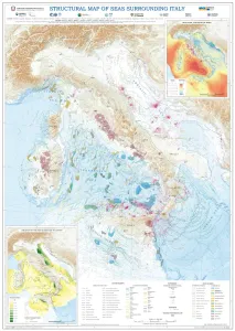
Using EMODnet Geology data, the Department for the Geological Survey of Italy (ISPRA) characterised the structural settings of the seas surrounding Italy. The EMODnet data, particularly from the "Geological events and probabilities" work package, provided insights into tectonic activity, including earthquakes, volcanoes, and submarine landslides. The EMODnet Bathymetry Digital Terrain Model (DTM) helped outline submarine volcanoes, while seabed rock data from the "Seafloor geology" work package aided in understanding geological strata. This comprehensive information allows for the identification of various marine geological settings, forming a solid basis for future studies on marine geohazard assessment, land management, and applied geology.
The EMODnet Biocheck tool was instrumental in harmonising and standardising the dataset collected from the in situ optical plankton recorder (LOKI), ensuring the data's accuracy and interoperability. This process facilitated the dataset's publication and compliance with FAIR principles, enhancing collaboration and innovation in marine research.
This study focused on developing an effective route planning methodology for unmanned sea vehicles (USVs), particularly Remotely Operated Vehicles (ROVs) combining EMODnet data and third-party systems.
The data on EMODnet Human Activities occurrence and distribution was used to investigate the regulations of activities and protection provided by Marine Protected Areas (MPAs) in the European Union (EU). This PhD research study, supported by CCMAR, CNRS, and INRAE research institutes, highlights the persistent data gap and limitations of current EU MPAs and serves as a benchmark for monitoring and future evaluation of MPA policies.
The Maritime Spatial Planning (MSP) Challenge is an open-source platoform developed by Breda University of Applied Sciences. It hels users manage the blue economy and marine enviornmeny by simulating the impact of decisions on energy, shipping, and marine life. The simulations encourage users to utilize the best available data for assessing the current status and planning the future development of sea space. The data includes EMODnet services, which were used in an MSP Challenge to map bathymetry, biology, human activity and seabed habitat data for a simulation game supporting educational and stakeholder engagement.
The Portuguese Institute for Sea and Atmosphere (IPMA), one of the EMODnet partners, is a state laboratory whose mission is to promote and coordinate scientific research, technological development, innovation and services on sea and atmosphere. IPMA is responsible for executing the geophysical, geological, geotechnical and environmental studies in the REPowereu project, which has the aim of developing up to 10 GW of electrical production centers in the offshore of Portugal, based on oceanic renewable energy until 2030.
The European Commission Directorate-General for Environment (EC DG ENV) has funded research in the Mediterranean Member States as part of the MEDREGION project to support the implementation of Good Environmental Status (GES) as defined under the Marine Strategy Framework Directive (MSFD).


, high-resolution bathymetric maps of Ireland’s coastal waters and offshore territory (top), photos of marine and seabed habitats (bottom left), and in situ and remote sensing approaches used for marine habitat mapping.")

, including overlaid datasets for submarine cable routes, offshore wind farm locations, and coastline data. © Osman Onur AKIRMAK. All rights reserved.")


