User organisation
The Faculty of Maritime Studies Kotor is part of the University of Montenegro, located in the coastal city of Kotor in Montenegro. Founded in 1959, the faculty is a prominent institution in Montenegro for maritime education and research. It offers BSc, MSc and PhD programs in maritime navigation, marine engineering, marine electrical engineering, and port management and logistics, as well as an MSc international interdisciplinary joint program in maritime environmental protection and management. These programs provide students with the expertise needed to tackle challenges in the maritime industry sector.
The faculty is committed to advancing research in marine and coastal environments, with a focus on sustainable practices, environmental protection, and offshore infrastructure development. It works closely with international and regional institutions, industry partners, and governmental bodies to foster innovative solutions in marine science and technology. The faculty also contributes significantly to the sustainable development of Montenegro's maritime sector, providing valuable expertise in the management and conservation of marine resources.
The faculty has extensive experience of participating in and coordinating EU co-financed projects including programs such as TEMPUS, ERASMUS + CBHE, and Interreg.
Challenges faced by the user
This study is part of a master's thesis preliminary work, focusing on developing an effective route planning methodology for Unmanned Sea Vehicles (USVs), particularly Remotely Operated Vehicles (ROVs). The primary goal is to visualise and analyse geospatial data—such as underwater routes, wind farms, and coastal features—by overlaying it on systems like OpenSeaMap or OpenCPN.
This data will assist in operational planning for unmanned marine vehicle routes, which will be developed based on the study of the marine ecosystem enhancing navigation and mission execution in complex maritime environments. The study is open access and available on GitHUB.
The study aims to allow users to display the downloaded EMODnet data within a specific, interactive region of interest (ROI) on a map using third-party software. Essentially, combining EMODnet data and third-party systems, such as OpenSeaMap or OpenCPN, to be displayed in a single frame for a more effective route plan for USVs.
EMODnet’s datasets played a critical role in addressing several challenges related to spatial data visualization and filtering. The main challenge was the integration and interactive filtering of multiple datasets. EMODnet’s standardized, high-quality and comprehensive array of marine datasets allowed to efficiently create interactive visualizations that not only supported spatial analysis but also helped users refine their areas of interest for specific applications. By combining multiple layers of data, an effective tool was developed that can be applied to marine spatial planning, infrastructure planning, and environmental assessments.
The ability to combine geospatial data from multiple sources has helped identify areas for renewable energy projects while ensuring compliance with environmental regulations, contributing to a greener, more sustainable future.
EMODnet services used
EMODnet Bathymetry's coastline data was used in understanding the depth variations, which is crucial for the proper placement of underwater infrastructure, such as offshore wind farms or submarine cables.
Additionally, EMODnet Human Activities' submarine cable dataset ensured the filtering process excluded areas where these cables exist, avoiding conflicts in potential development zones. And EMODnet Human Activities' wind farms data, containing the locations of offshore wind farms across Europe, was critical for identifying and avoiding overlap with active projects.
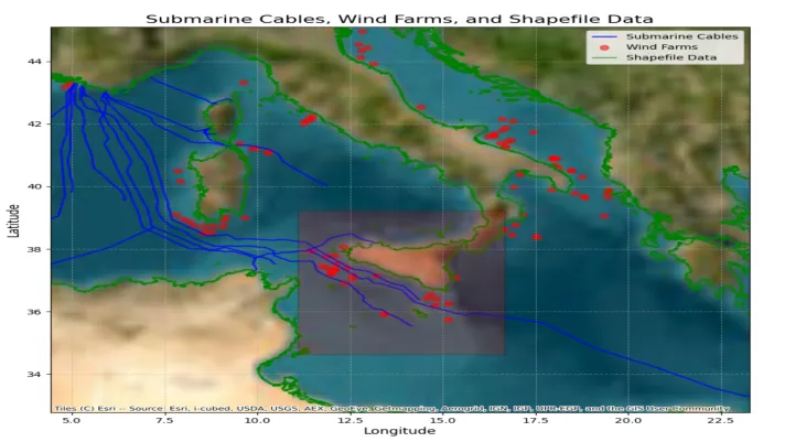
Interactive map showing the filtered geospatial data within the selected Region of Interest (ROI), including overlaid datasets for submarine cable routes, offshore wind farm locations, and coastline data, visualized on a basemap. The ROI, defined by the user, highlights the area of interes, and the filtered data within this region is displayed for further analysis and decision-making. © Osman Onur AKIRMAK. All rights reserved.
EMODnet’s open-access datasets have been invaluable in enhancing the tool we developed for geospatial analysis. By integrating multiple data layers into a cohesive framework, we've been able to streamline the process of selecting regions of interest, filtering data, and exporting it for further analysis, significantly improving our efficiency and accuracy.