Organisation
The Department for the Geological Survey of Italy of the National Institute for Environmental Protection and Research (ISPRA) is the official geological mapping office of Italy. Besides its main task of map production, the Geological Survey of Italy carries out research activities on geology, stratigraphy, biostratigraphy, tectonics, petrography, and geomorphology and participates in international projects at both EU level, such as GSEU, and beyond EU, such as the UNESCO "Petra Palace Tomb" Project. It is a Partner of the EMODnet Geology Consortium, coordinates the "Geological events and probabilities" work package, and provides contributions to other work packages, also thanks to the comprehensive and detailed database associated with the production of the Geological Map of Italy (CARG Project).
EMODnet Products Used
Data gathered within EMODnet Geology, particularly those included in the "Geological events and probabilities" work package (i.e. earthquakes, volcanoes, submarine landslides, fluid emissions, tsunamis and Quaternary tectonics) provided the opportunity to obtain an overview of information connected to tectonic activity within Italy.
The EMODnet Bathymetry Digital Terrain Model (DTM) helped outline submarine volcanoes which, together with earthquakes and tectonics, represent the features which may originate potential geohazards. In addition, rocks cropping out on the seabed (deriving from the EMODnet Geology "Seafloor geology" work package) helped characterise the geological successions of strata in marine areas.
The combination of the aforementioned information allows the identification of different types of marine geological settings and represents a solid basis for future studies and further investigations addressing marine geohazard assessment, land management and applied geology.
Challenges faced
The participation and activities carried out within EMODnet Geology have increased the role and visibility of the "Marine Geology" unit of the Department of the Geological Survey of Italy and provided the opportunity to coordinate an Italian working group on features included in the EMODnet Geology work package "Geological events and probabilities”. EMODnet has promoted a systematic inventory of marine geology data in Italian seas, stimulating cooperation with geological survey organizations of other countries and with other national research institutions working on marine areas. The availability of comprehensive datasets freely accessible and downloadable simplifies the approach to studies addressing any aspect of the marine environment and reduces the investments in the preliminary search necessary to start any investigation.
References
Refs: Fiorentino et alii (Eds) (2025) - Structural map of seas surrounding Italy. Dept. Geological Survey of Italy - ISPRA.
EMODnet Geology provides the opportunity to gather, organise, disseminate and freely access (according to FAIR principles) the large amount of data collected in submerged areas during the last decades as well as to elaborate thematic maps.
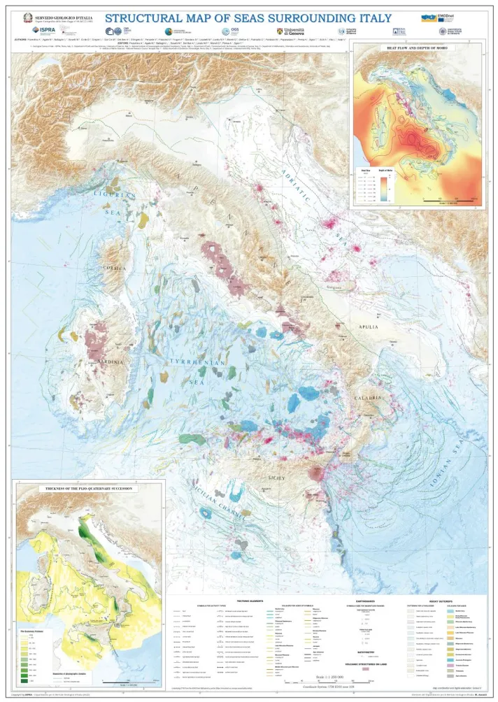
Structural map of seas surrounding Italy depicting information on the types of tectonic deformations, earthquakes location and magnitude, distribution and lithology of submarine volcanic structures and rocky outcrops. They help characterise the structural settings of marine areas. Complementary information on heat flow, depth of Moho and thickness of Plio-Quaternary succession is provided in the inset maps. (Copyright/licence: © ISPRA - Department for the Geological Survey of Italy. All rights reserved).