The Institut de Ciènces del Maris (ICM) is the largest research institute of the Spanish National Research Council dedicated to marine research and aims to conduct and promote novel interdisciplinary marine research which addresses several challenges faced by the marine environment.
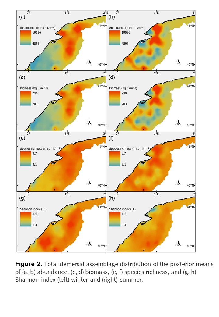
The Mediterranean Sea is the largest semi-enclosed sea in the world and is put under excessive pressure from the increased demand for marine resources, particularly from the over-fishing of demersal species. In order to predict the impact of anthropogenic activities and climate change in marine ecosystems, an improved understanding on the spatial patterns of marine communities and how they vary seasonally is required. To investigate these dynamic environments which vary seasonally, data are required on several physical factors such as temperature, salinity, fluorescence and type of substrate in order to predict the impact of anthropogenic pressures on the demersal marine community. The study conducted by ICM, required several fine-scale datasets on physical and biological characteristics from a region of the Mediterranean which is particularly productive and highly exploited during two seasons.
EMODnet Seabed Habitats classified substrate types described in the broad-scale predictive habitat map for Europe (EUSeaMap 2019) were used to identify regions of fine mud, sand and sandy mud. This data was used as one of many predictor variables to model spatial patterns of abundance, biomass and biodiversity of demersal communities of the North-West Mediterranean. It was the only dataset that was not collected during two scientific surveys conducted in 2013, as part of the Spanish National Project ECOTRANS. EMODnet supplied the single integrated and harmonised dataset that would have otherwise involved a time consuming and expensive research cruise which would have reduced the time required for the necessary sampling of several other physical and biological variables needed to build a model on seasonal spatial patterns. Without knowledge of substrate type, the seasonal and dynamic changes in the spatial patterns of demersal (seafloor dwelling) communities would have been incomplete.
The study has revealed the importance of spatial patterns of demersal communities and how it varies seasonally – driven specifically by changes in sea surface temperature. These results promote the need for monitoring schemes which capture seasonal change in demersal communities to form a comprehensive marine spatial planning framework. The substrate types described in EUSeaMap will continue to be an important source of data to predict changes in biodiversity associated with seasonal changes within a dynamic environment. Research outcomes are essential to advise public stakeholders such as; governments to introduce management strategies, such as seasonal fishing restrictions, in order to protect sensitive marine communities against increasing anthropogenic pressures.
© (Vilas et al., 2020)