The user organisation
Cyprus Subsea Consulting and Services C.S.C.S. Ltd (CSCS) was founded in December of 2012 in Nicosia, Cyprus. CSCS blends academic and technical expertise with seagoing and survey experience to carry out scientific research, commercial and governmental projects all over the world.
CSCS specializes in marine robotics and autonomous systems. Since its beginning, CSCS has been serving the public and private sector with equipment maintenance, rentals and official resales, as well as data collection, analysis and reporting services. One of the primary missions of CSCS is to develop, operate and maintain ocean gliders and related services for use in science and industry. Cyprus Subsea team has over 15 years of glider operation experience with more than dozens of launches and successful recoveries representing several glider-years and tens of thousands of profiles.
Challenges faced by the user
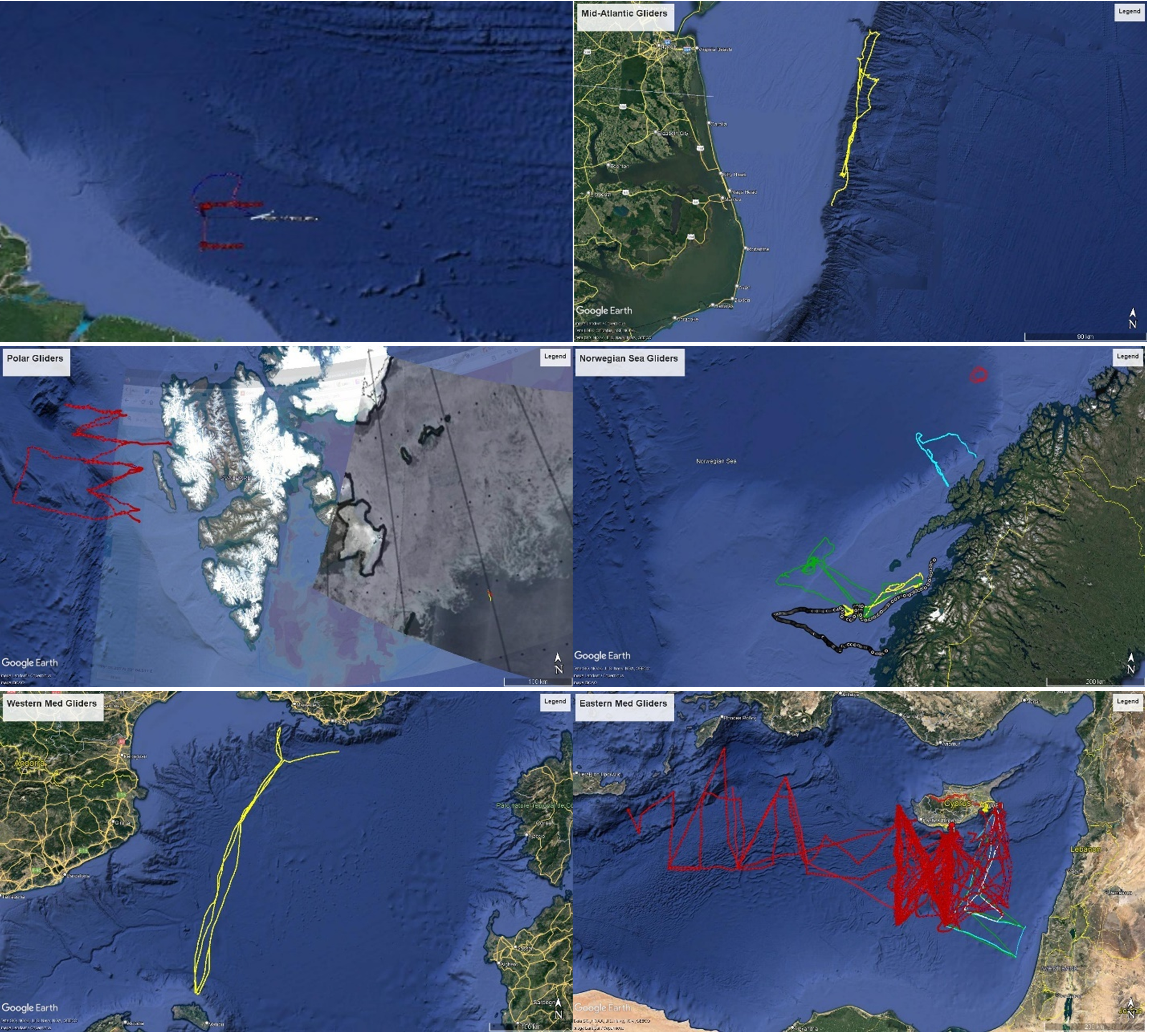
CSCS carries out glider missions all over the world. Gliders are small autonomous underwater vehicles that use changes in displacement to change buoyancy, and internal mass movements to attain pitch and roll movements. Coordinated by an on-board flight computer, this slow but very efficient profiling device collects data as it descends and ascends, sending the results and receiving commands every few hours when at the surface for many months at a time. Because the horizontal speed of ocean gliders (around 25 cm/s) is comparable to ocean currents, and the density stratification must be accounted for when preparing the gliders, local oceanographic data are critical to mission planning. In some cases, such as surface freshwater lenses or strong barotropic currents, the risks of control loss are too great. This is rare, fortunately, but it is always a good idea to design a mission to take advantage of prevailing currents, and to adjust the glider ballast to properly match the expected ocean density, and to know the expected density range, which together allows them to calculate the maximum possible speed using the remaining volume change available. It also allows CSCS to calculate how long the mission will last, since the main energy draw for most glider set-ups is the buoyancy pump. In some areas, ice coverage is also needed: both historically and in real time. The map below illustrates the glider missions carried out by Cyprus Subsea and the wide range of oceanographic conditions CSCS has faced.
EMODnet services used
The EMODnet Physics portal is an excellent place to find and access ocean observations of known quality all around the world. By searching the portal, CSCS are able to build and save searches, request and receive data, and verify our calculations for density stratification and current magnitude and direction (and the spatial and seasonal variability of those). Combined with modeling and remote sensing data from Copernicus Marine Service (CMEMS), they become familiar with the oceanographic conditions of the operational area before they even deploy the glider. Once the glider is launched, this picture is obviously updated with the observations from the glider itself (and vessel in some cases, as well as real time forecasts and remote sensing images). CSCS have also been able to reach out to groups who collect and publish data for further information, because they can see who is active in each region. Without this ground-truth data, they would rely purely on modeling and remote sensing data, which have severe limitations at the time and space scales of glider missions. Of course, in situ observations are also limited in their time and space coverage, which make our glider mission plan and risk assessment much more robust when all three sources are combined.
Impact of EMODnet
By using EMODnet, CSCS has a much better track record of glider operations, which will help them gain more customers. Producing and providing a well-supported mission plan also indicates our level of professionalism and attention to detail, which instils confidence in our customers. The commercial sector has been slow to accept gliders for environmental monitoring but with professional and sea-proven missions, this is changing. Our success will mean that more oceanographic data at lower cost can be collected compared to most other means. If gliders become a more commonplace operational tool, then marine safety and security will improve (e.g., better knowledge of currents for pollution fate modelling, better storm forecasts, and better ecosystem management). CSCS plans to continue to use EMODnet, which grows more and more useful as more data are included.
Media