By Bart Vanhoorne, EMODnet portal technical team member and VLIZ IT Division manager and Dr. Conor Delaney, EMODnet Technical Coordinator
The EMODnet Catalogue serves as the central metadata repository for the European Marine Observation and Data Network (EMODnet), at its core, the EMODnet Catalogue functions as a comprehensive discovery platform that enables researchers, policy makers, industry professionals, the general public, and machines to locate and access marine data and data products from across Europe's seas. The EMODnet Portal is your one-stop-shop for in situ data of the marine environment with data and data products across seven discipline-based themes, providing a unified entry point to what was once a fragmented landscape of marine data sources.
The catalogue operates on GeoNetwork, an open-source catalogue application that manages spatially referenced resources through standardized metadata records. This technical foundation enables the EMODnet Catalogue to provide robust search capabilities, allowing users to discover datasets through spatial, temporal, and thematic filters. The EMODnet central catalogue offers a Catalogues Service for the Web (CSW) and JSON-LD endpoint, two widely used standards to synchronize or search collections of metadata for data, services and related information objects and export the metadata in a range of formats.
Users can access the EMODnet Catalogue through multiple pathways. The primary interface is available through the EMODnet Portal, where visitors can search and browse metadata records, and download data products. Additionally, the catalogue integrates with EMODnet's Map Viewer, enabling users to visualize data geographically and access download links directly from the spatial interface.
As demand for marine data access continues to grow across science, policy, and industry, so does the need for reliable, scalable, and future-proof systems. Upgrading the EMODnet Catalogue to the latest version of GeoNetwork represents a step forward in enhancing performance, security, and interoperability. More than a technical exercise, this upgrade unlocks new possibilities for users and data providers alike paving the way for easier integration and faster search. These improvements help ensure that EMODnet continues to deliver cutting-edge services to a growing and diverse user base in the marine data community.
GeonetWork is a web-based application that allows users to describe datasets. That description is in general called “metadata”, and at its minimum contains a title, a contact, a temporal and geographic scope and a way to access the data (product). For EMODnet, the bulk of these datasets are linked to coordinates, so all of them have a geographic coverage, and can easily be represented the EMODnet map viewer. The metadata describing the EMODnet datasets is searchable and discoverable via the GeoNetwork based EMODnet catalogue for both humans and machines.
The GeoNetwork instance on the EMODnet portal is used to automatically harvest the metadata from the 8 thematic lots, each of which have their own metadata catalogue. The thematic lots of EMDOnet are responsible for managing their metadata within their own technical infrastructure, this is subsequently harvested by the EMODnet catalogue. Some lots also have GeoNetwork, other lots have developed a custom tool or workflow.
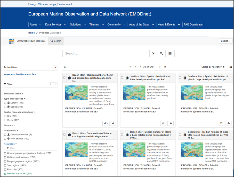
Figure 1. A screen shot of the EMODnet Catalogue.
The EMODnet Catalogue hosted on GeoNetwork and the service that it provides is the essential building block of the architecture of the EMODnet Spatial Data Infrastructure. It is a key element to the success of the Centralisation for EMODnet, when we moved from 8 separate to portals to one unified EMODnet portal. If you refer to the Central Portal architecture design schema that was published in 2020 by the EMODnet Portal team (https://maritime-forum.ec.europa.eu/contents/updates-emodnet-architecture_en) you can see where GeoNetwork was indicated as an essential component to properly manage the metadata of a federated system, which EMODnet is.
GeoNetwork is open-source software that is continuously developed by a vibrant development community. The software is in constant development by an open-source community, this allows us to easily address bugs and request for new features. Each release brings new features and improvements. Previously, EMODnet was using a customized version from Digitaal Vlaanderen, which at that time had one an extra essential feature (DCAT-AP) support, needed for machine-to-machine communication to other portals. This old version (3.8) has now been replaced by the latest (4.4) version which has all of these essential (but also many new) features build-in. A few examples:
Much easier and standard (docker) installation (1 day, vs. 1 week for i.e. undoing customizations in the old version, etc..)
Excellent search capabilities and speed via Elasticsearch
Web components now available, to integrate GeoNetwork in other websites (not yet explored by EMODnet)
Thesaurus support (i.e. INSPIRE, to explore)
Improved harvesting (it was not possible to harvest from newer GeoNetwork version with previous version)
Improved security (many high-level CVE bugs were fixed) and stability (no more docker crashes)
Easier customization of faceted search and labels (planned in 2025 via a dedicated Task Force)
The current (4.4) version is exactly what we aimed for (at least for technically)!
Previously, we applied GeoNetwork updates on an ad-hoc basis (i.e. once per 1-2 years). From now on, we plan to follow the latest releases as soon as they come out. Since we are using docker and the standard build, this will be straightforward. Below is an overview of the version history of the EMODnet deployments of GeoNetwork:
2016 GeoNetwork 3.0.4, multiple nodes,
2022 GeoNetwork 3.8 custom build, on docker,
2025 GeoNetwork 4.4.7, on docker.