Background
The EU and China both have both common and differing best practices approaches in ocean governance and for the sharing and managing data and data products. The EU and China collaborative projects (EMODnet & CEMDnet) establishing an effective Partnership on marine data are a step towards this common objective.
EMODnet Partnership for China and Europe (EMOD-PACE)
The EMOD-PACE project has 18 European partner organisations, started officially on 19 February 2020 and will run for a period of 30 months. The project aims to deliver a major part of the EU contribution to the EU-China Blue Partnership for the Oceans.
China-EU Marine Data Network Partnership (CEMDnet)
‘中国-欧盟海洋数据网络伙伴关系’
In response to the EMOD-PACE at EU side, NMDIS started its work on developing the China-EU Marine Data Network Partnership (CEMDnet), which aims at connecting the EMODnet and data sharing platform running by NMDIS, to facilitate marine data interoperability between EMODnet and NMDIS. Meanwhile, EMODnet and NMDIS will jointly work on marine data and information management services, standards and product R&D in the fields of ocean reanalysis, seabed habitat mapping, ecological vulnerability and coastal zone adaptability, etc.
CEMDnet was officially launched in February 2020 for a period of 30 months. The implementation of the project is expected to make positive contributions to the China-EU Blue Partnership for the Oceans.
The overall aim of this project is to promote international ocean governance with China and support the implementation of global commitments by making ocean marine data and data products more easily accessible and by providing better data and data products. Concrete EMOD-PACE objectives are summarised and described as follows:
- Establish a solid and effective working relationship between EMODnet and Chinese counterparts, in particular the National Marine Data and Information Service of China (NMDIS).
- Support processes related to collaboration with China with a view to improve discovery of and access to marine data and data products by establishing interoperability of data and information systems.
- Support ocean-related policy objectives and policy dialogues as well as to enhance cooperation in key areas of ocean governance.
- Facilitate political convergence towards a collective approach to tackling global ocean challenges such as climate change, marine litter, and environmental protection and biodiversity, in particular in the context of the Convention for Biological Diversity (CBD).
- Support the use of internationally agreed standards for marine data, both by the public and private sectors.
In detail, the project will strengthen the relationship between EMODnet and NMDIS by:
- Setting up a bilingual English-Chinese project information website providing a gateway to the project results.
- Maximizing interoperability between EU and Chinese marine data services, and data products and information systems.
- Comparing European and Chinese numerical ocean models by
- comparing reanalysis and model results with historic data;
- analysing the applicability of each side's models for seabed habitat and ecosystem vulnerability.
- Providing reliable information to support coastal adaptation on the sea route between China and Europe.
EMOD-PACE work plan
EMOD-PACE runs for a duration of 34 months. The work packages (WP) are as follows:
WP0 - Project Coordination, Management and Communication
WP1 - EU-China Web Portal & creation of interoperable information system linking EMODnet with NMDIS
WP2 - Establishing data interoperability between EMODnet and NMDIS
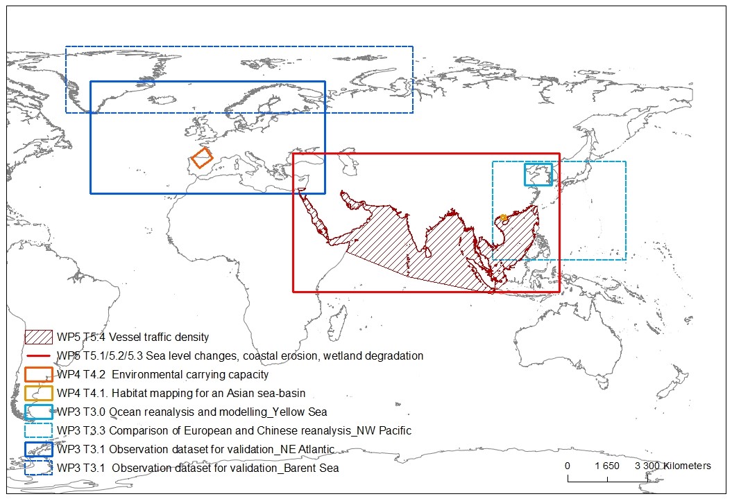
WP3 - Comparison of European and Chinese Models for Regional Sea Reanalysis
WP4 - Comparison of European and Chinese models for seabed habitat and ecosystem vulnerability
WP5 - Coastal Adaptation
WP5 is providing data/information products (i.e. digital maps) for the Maritime Silk Route Seas for the following:
- Relative and absolute sea level changes.
- Coastal erosion.
- Wetland degradation.
- Vessel traffic density.
Data Information
Marine data sharing
The publication and sharing of marine data follows established best practice. The EU shares marine observation data through EMODnet and ocean modelling data through Copernicus Marine Service. In general, European marine observation data originates with the Member States, and is aggregated by EMODnet for publication on the EMODnet Central Portal as a centralised hub for European marine data.
In China NMDIS is responsible for national marine data collection, management, processing and distribution, and the construction and operation of the marine environmental and geographical information service platform, undertaking quality control and evaluation of marine data and information products. In addition, it is responsible for operational tide and tidal current forecast, sea level change prediction and evaluation and development and release of marine environment data re-analysis products.
Optimising data sharing and user access between EMODnet and NMDIS – the Challenge
Marine observations are fundamentally geospatial in nature. An observation consists of measurements associated with any particular parameter (temperature for example) at a location for a certain time. Each component of the observation can vary depending on standards used, for example:
- Temperature, Fahrenheit, Celsius and Kelvin are all valid measurements.
- Time can vary depending on local sunrise and sunset.
- Location description can be depending on the geospatial grid being used to describe the Earth.
Science can address some of these problems, for example, through the development of standardised units for measurement and by recording a universal time. Also, in general the World Geodetic System (WGS84) is used as the reference coordinate system, but not always, and the geographic coordinate system (datum and projection) will vary depending on the region in the world, and also on the area being mapped).
The necessity to share scientific quality environmental data online for the support of research, policy formulation and implementation and others, has led to the realisation that observations need to be annotated by metadata (data that describes data), to provide more context to the observations. For example, who made the observation, what were the general weather conditions or what datum was the observation location made against.
With EMODnet, EU has gained considerable experience over the past decade with providing users access to a wide range of multidisciplinary datasets at European level by fostering interoperability of data collected and stored by different countries, institutes and thematic and regional data assembly initiatives. In this project, we will be looking at ways to optimise data sharing and user access between EMODnet and NMDIS. In particular it will look at ways to improve interoperability between EMDOnet geodata servers and NMDIS geodata servers. For example, part of this project we will examine the suitability of the following aspects facilitating the exchange and interoperability of data from different sources:
- Open Geospatial Consortium web services.
- Metadata standards
- File format standards.
The project delivers a searchable catalogue of EMODnet and NMDIS data that can be either downloaded or displayed in a web map. This catalogue will exist in duplicate on both the EMODnet Central Portal and NMDIS portal
Project Partners
EMOD-PACE Consortium
Role | Consortium Members | Nationality | Logo |
|---|---|---|---|
Leader | Seascape Belgium bvba (SSBE) | Belgium | |
Member | Fundación AZTI – AZTI Fundazioa (AZTI) | Spain |  |
Member | Fondazione Centro Euro-Mediterraneo sui Cambiamenti Climatici (CMCC) | Italy |  |
Member | Consulenti per la Gestione Aziendale (COGEA) | Italy |  |
Member | Stichting Deltares (Deltares) | The Netherlands |  |
Member | Danmarks Meteorologiske Institut (DMI) | Denmark |  |
Member | EOMAP GmbH & Co. KG (EOMAP) | Germany | |
Member | ETT S.p.A. (ETT) | Italy |  |
Member | Geologian tutkimuskeskus (GTK) | Finland | |
Member | Hellenic Centre for Marine Research (HCMR) | Greece |  |
Member | Institute français de recherché pour l’exploitation de la mer (IFREMER) | France | |
Member | Joint Nature Conservation Committee (JNCC) | UK |  |
Member | Mariene Informatie Service BV (MARIS) | The Netherlands |  |
Member | Istituto Nazionale di Oceangrafia e di Geofisica Sperimentale (OGS) | Italy | |
Member | Service Hydrographique et Océanographique de la Marine (SHOM) | France | |
Member | Swedish Meteorological and Hydrological Institute (SMHI) | Sweden | |
Member | Vlaams Instituut voor de Zee (VLIZ) | Belgium | |
Subcontractors | Bilbomatica S.A. | Spain |  |
Subcontractors | Geological Survey of Denmark and Greenland (GEUS) | Denmark |  |
Subcontractors | TNO | Netherlands |  |
*The European Commission inter-services Steering Committee is charied by Directorate-General Maritime Affairs and Fisheries (MARE) and Foreign Policy Instruments.
National Marine Data and Information Service (NMDIS)