European Marine Observation and Data Network (EMODnet)
Use Cases
Submit your Use Case
To understand the full benefits of EMODnet, users are kindly asked to describe how EMODnet supports them in their daily work and activities.
If you have developed an application using EMODnet products that you would like to share with us or if you use EMODnet data for other purposes, submit your use case by contacting helpdesk@emodnet.ec.europa.euuuuueends e-mail)
EMODnet Chemistry supported the UNESCO GO2DAT initiative by providing harmonised oxygen data, metadata standards, quality control procedures, and best practices, alongside SeaDataNet infrastructure. These services were used by GO2DAT and the wider global ocean data community to design a federated, interoperable, and high-quality global system for ocean oxygen data.
The Joint Research Centre leads the Technical Group on Marine Litter (TG ML), and has been working together with EMODnet Chemistry since 2016 on the development of various marine litter databases, to which European Member States provide data. EMODnet Chemistry gathers the data from these databases to produce aggregated, harmonised and validated data collections, that TG ML further uses to analyse progress towards the Marine Strategy Framework Directive's Good Environment Status.
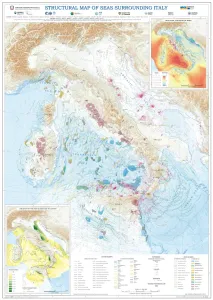
Using EMODnet Geology data, the Department for the Geological Survey of Italy (ISPRA) characterised the structural settings of the seas surrounding Italy. The EMODnet data, particularly from the "Geological events and probabilities" work package, provided insights into tectonic activity, including earthquakes, volcanoes, and submarine landslides. The EMODnet Bathymetry Digital Terrain Model (DTM) helped outline submarine volcanoes, while seabed rock data from the "Seafloor geology" work package aided in understanding geological strata. This comprehensive information allows for the identification of various marine geological settings, forming a solid basis for future studies on marine geohazard assessment, land management, and applied geology.
The EMODnet Biocheck tool was instrumental in harmonising and standardising the dataset collected from the in situ optical plankton recorder (LOKI), ensuring the data's accuracy and interoperability. This process facilitated the dataset's publication and compliance with FAIR principles, enhancing collaboration and innovation in marine research.
This study focused on developing an effective route planning methodology for unmanned sea vehicles (USVs), particularly Remotely Operated Vehicles (ROVs) combining EMODnet data and third-party systems.
The data on EMODnet Human Activities occurrence and distribution was used to investigate the regulations of activities and protection provided by Marine Protected Areas (MPAs) in the European Union (EU). This PhD research study, supported by CCMAR, CNRS, and INRAE research institutes, highlights the persistent data gap and limitations of current EU MPAs and serves as a benchmark for monitoring and future evaluation of MPA policies.
The European Commission Directorate-General for Environment (EC DG ENV) has funded research in the Mediterranean Member States as part of the MEDREGION project to support the implementation of Good Environmental Status (GES) as defined under the Marine Strategy Framework Directive (MSFD).
The University of Southampton and its Southampton Marine and Maritime Institute is a major European centre for oceanography and marine geoscience. The Southampton Marine and Maritime Institute (SMMI) is the largest entity of its kind in the world, with expertise in everything from naval architecture to social sciences and work to address issues in the natural ocean environment (marine) and human use of the sea (maritime).
MPA Europe project (https://mpa-europe.eu/). The MPA Europe project is using a holistic range of measures of biodiversity from species to ecosystems, including habitats, to map the optimal areas for Marine Protected Areas implementation in Europe. Areas will be prioritised using systematic conservation planning software, which enables alternative weighting of variables and multiple scenarios and thus support wider marine spatial planning. OBIS (https://obis.org/) is responsible for WP3, which will generate species distribution models for at least half of all marine species in Europe to be utilized in the prioritization process.
EOSC-Future is an EU-funded H2020 project that lasted from April 2021 to the end of March 2024. The project implemented the European Open Science Cloud (EOSC). EOSC provides European researchers with a virtual environment for sharing and accessing research data across borders and scientific disciplines. EOSC-Future developed and operated key components of the EOSC core: the services required for the operation of the EOSC. Some examples of the services developed within EOSC Future are the EOSC Marketplace, the EOSC Interoperability Framework, the EOSC Catalogue.


, including overlaid datasets for submarine cable routes, offshore wind farm locations, and coastline data. © Osman Onur AKIRMAK. All rights reserved.")


