The ground-breaking EU-China collaborative project EMOD-PACE (EMODnet Partnership for China and Europe) has now entered its second month in April 2020 after kicking-off mid-February.
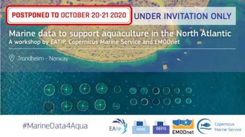
The European Aquaculture Technology and Innovation Platform (EATIP), EMODnet and Mercator Ocean International together with DG MARE and DG DEFIS postponed the event “Marine data to support aquaculture in the North Atlantic” to 20-21 October 2020 in Trondheim,
At the start of each New Year, it has become our tradition to take a moment to reflect on the past, take stock of our achievements and look forward to what the coming year will bring for our growing network of partners and users.
We’re excited to announce the release of a new data product available on EMODnet Chemistry: a collection of new digital maps of contaminants. These maps visualise data from more than 100 data providers, following intense work by EMODnet Chemistry of data aggregation, harmonization, analysis and validation.
We’re delighted to announce the release of a new data product available on EMODnet Human Activities: traffic density maps. Based on AIS data from ships, these maps were prepared by the European Maritime Safety Agency (EMSA) in response to a series of ad-hoc requests to complement specific studies or projects.
Communication and Partnership Relations Officer ‐ Secretariat of the European Marine Observation and Data Network (EMODnet). Deadline extended! Closing date for applications: 13 January 2020 10:00 CET
We are delighted to announce the release of the film and report of Open Sea Lab II! We hope that these outputs reflect the openness, creativity and dynamism of this three-day, deep-dive into open marine data.
Do you have some sleeping marine biological datasets that can be useful for others? Apply for an EMODnet Biology data grant and contribute to expanding our current knowledge on ecosystem functioning and the status of biodiversity. This call seeks grant proposals that will help EMODnet Biology to increase the amount of data made available and to cover existing geographical, temporal and/or taxonomic data gaps.