European Marine Observation and Data Network (EMODnet)
Use Cases
Submit your Use Case
To understand the full benefits of EMODnet, users are kindly asked to describe how EMODnet supports them in their daily work and activities.
If you have developed an application using EMODnet products that you would like to share with us or if you use EMODnet data for other purposes, submit your use case by contacting helpdesk@emodnet.ec.europa.eu.
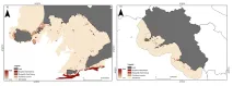
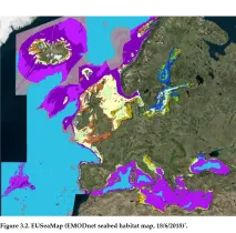
The National Interuniversity Consortium for Marine Science (CoNISMa) conducted a study to assess the natural capital across the Gulf of Naples and the wider Campania region, areas of importance to Italy’s economy. EMODnet Seabed Habitats broad-scale habitat map for Europe (EUSeaMap 2019) supported the authors’ research by providing vital data on habitat boundaries within the broader Campania region. This resource allowed the authors to identify four main macro-habitats which could be used to quantify the value of marine natural capital stocks.
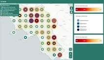
Wind, wave and sea level data are valuable sources under the GRISIS multidisciplinary and holistic analysis of natural risks. EMODnet Physics is making available aggregated and easy to use products that can be easily machine-to-machine integrated into the innovative multi-risk technological platform for management and mitigation of multiple risks that GRISIS project is developing in order to build resilence plans and infrastructure in South Italy.
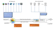
In close collaboration with OceanOPS, EMODnet Physics is connecting multiple data sources with the OceanOPS metadata repository thanks to the unique identification system managed by OceanOPS. This is automatically reducing the duplication issues related to multi data sources and increasing the quality of the information system developed by EMODnet Physics. At the same time, EMODnet Physics is connecting OceanOPS to networks that are not yet under its radar to continuously improve the monitoring of the Ocean Observing systems operating in the global ocean.
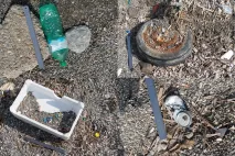
EMODnet Chemistry provided valuable contributions to the completion of a Joint List of Litter Categories for Marine Macrolitter Monitoring that includes the litter types occurring in the coastal and marine environment. The list can be used to enable comparable monitoring across the European Seas and beyond, as well as across different compartments of the marine environment.
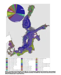
A joint Copernicus Marine and EMODnet data catalogue for the Marine Strategy Framework Directive (MSFD) has been developed. It gathers all relevant marine data products from Copernicus Marine Serviceand EMODnet for all the MSFD descriptors (except Descriptor 4) in the Baltic Sea.
SOCIB Dapp is a web based client application, developed by the SOCIB Data Centre, intended to display and download deployments data either from SOCIB or third party portals such as EMODnet and Copernicus Marine. Dapp provides additional features such as: Browsing and displaying any deployments made by SOCIB, creating customized maps with several deployments and WMS map layers.
The Helsinki Commission (HELCOM), also known as the Baltic Marine Environment Protection Commission, is an intergovernmental organisation and regional sea convention in the Baltic Sea area. It comprises ten Contracting Parties (Denmark, Estonia, Finland, Germany, Latvia, Lithuania, Poland, Russia, Sweden and the EU) forming a platform for environmental policy making at a regional level, with the goal of protecting the Baltic Sea from all sources of pollution through intergovernmental co-operation.
Wageningen Marine Research Institute is a part of the wider Wageningen University and Research centre. The marine institute conducts independent scientific research and provides contributions and advice on marine monitoring, spatial planning, sustainable marine exploitation, fisheries and nature-based solutions to climate change.
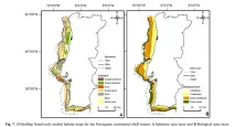
This study was published by authors from a range of universities and research institutes. The lead author is a representative of the Department of Biology of Universidade de Aveiro, a Portuguese university.