European Marine Observation and Data Network (EMODnet)
Use Cases
Submit your Use Case
To understand the full benefits of EMODnet, users are kindly asked to describe how EMODnet supports them in their daily work and activities.
If you have developed an application using EMODnet products that you would like to share with us or if you use EMODnet data for other purposes, submit your use case by contacting helpdesk@emodnet.ec.europa.eu.
The Horizon Europe MSP4Bio project used EMODnet multidisciplinary marine in situ data, including from Bathymetry, Biology and many other thematic data, to inform an Ecological-Socio-Economic (ESE) management framework used for science-based MSP to safeguard and restore biodiversity in a coherent European MPA network.
With over 300,000 water column profiles, in both coastal and deep sea areas, the National Oceanographic Data Centre at OGS manages the most comprehensive marine data storage in Italy. The multidisciplinary archive includes data since 1909 up to now. It ranges from physics to chemistry, from biology and geology to meteorology. Data are mainly collected by Italian institutions within the Mediterranean Sea basin, but also by other countries within neighbouring sea basins. Near real-time data are consistently integrated into the historical archive.
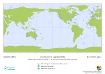
One of the main goals of OceanGliders, as part of GOOS, is to monitor and promote the activity of the glider observing network. The goal is not to provide data, but to document and give guidance on how to share someone’s glider activity, in order to raise their visibility and the visibility of gliders as whole, as concerns long-term sustained observing for societal benefit.
CSCS carries out glider missions all over the world. Gliders are small autonomous underwater vehicles that use changes in displacement to change buoyancy, and internal mass movements to attain pitch and roll movements. Coordinated by an on-board flight computer, this slow but very efficient profiling device collects data as it descends and ascends, sending the results and receiving commands every few hours when at the surface for many months at a time.
The Euro-Mediterranean Center on Climate Change (CMCC) has developed a first version of a web application with the “Total Sea Level” variable from EMODnet Physics. This solution presents a demonstrator of end-user application and decisional support dashboard systems to support public authorities in their daily management activities.
Wind, wave and sea level data are valuable sources under the GRISIS multidisciplinary and holistic analysis of natural risks. EMODnet Physics is making available aggregated and easy to use products that can be easily machine-to-machine integrated into the innovative multi-risk technological platform for management and mitigation of multiple risks that GRISIS project is developing in order to build resilence plans and infrastructure in South Italy.
In close collaboration with OceanOPS, EMODnet Physics is connecting multiple data sources with the OceanOPS metadata repository thanks to the unique identification system managed by OceanOPS. This is automatically reducing the duplication issues related to multi data sources and increasing the quality of the information system developed by EMODnet Physics. At the same time, EMODnet Physics is connecting OceanOPS to networks that are not yet under its radar to continuously improve the monitoring of the Ocean Observing systems operating in the global ocean.
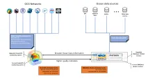
A joint Copernicus Marine and EMODnet data catalogue for the Marine Strategy Framework Directive (MSFD) has been developed. It gathers all relevant marine data products from Copernicus Marine Serviceand EMODnet for all the MSFD descriptors (except Descriptor 4) in the Baltic Sea.
Assist in Gravitation and Instrumentation (AGI) srl., was created as a spin-off of the Italian National Institute for Astrophysics (INAF). They recently developed the OS‑IS®(Ocean Seismic – Integrated Solution) technology, which is based on high sensitivity accelerometers to measure the sea-state (waves significant height and period) from inshore land.
The in situ data and wave nowcast products provided by EMODnet Physics and Data ingestion are useful tools for Outdoor Portofino, a company that promotes sport tourism and environmental education, to safely plan activities and promote sustainability for eco-friendly tourism. The company offers a wide package of lessons, tour guides and renting for outdoor activities and promotes marine conservation projects.