Dear EMODnet partners, colleagues and friends,
A very Happy New Year to you all! The EMODnet New Year’s letter is something of a tradition, written by the Head of the EMODnet Secretariat. In 2024, the baton passes to me, Kate Larkin, as I took on the role of Head of Secretariat in Spring 2023. On behalf of the EMOD-network I wish the previous Head, Jan-Bart Calewaert, well in his new activities in the global ocean data domain, whilst he remains a trusted advisor to EMODnet.
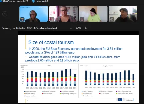
On 26-27 September 2023, EMODnet and EC DG MARE co-organised the online workshop “EMODnet Marine Data for Coastal Tourism”. The workshop assessed data requirements, data uses and data sharing opportunities, with diverse stakeholders from the private sector, research, policy and NGOs.
The European Marine Observation and Data Network (EMODnet) programme is designed to assemble existing, but fragmented and partly inaccessible, marine data and to create contiguous and publicly available information layers which are interoperable and free of restrictions on use, and which encompass whole marine basins.
On 27-30 November over 340 partners, associated partners, and stakeholders of the European Marine Observation and Data Network (EMODnet) gathered in Brussels for the third EMODnet Open Conference and Jamboree. The week kicked off with a Partner Jamboree with the >120 partners exchanging on their latest service developments and joint activities. The Open Conference was a public event, moderated by Karen Coleman.
Before the plenary stage opened for the EMODnet Open Conference 2023, the EMODnet community convened for the EMODnet Partner Jamboree 2023—an exclusive gathering of EMODnet partners and Associated Partners. This pre-conference event provided a unique setting for in-depth discussions, partner meetings, cross-thematic dialogues, and collaborative endeavors, setting the stage for the subsequent conference.
On 29th November, the two EC marine data services EMODnet and Copernicus Marine Service launch a joint statement on the EU in situ marine data landscape. The statement explains the complementarity between the two EU marine knowledge assets, and explains how the services work together, following a high-level agreement between DG DEFIS and DG MARE and the signature of Memorandum of Understanding (MoU) in 2016.
On 26-27 September 2023, EMODnet together with the European Commission DG MARE organised an online workshop on ‘’EMODnet Marine Data for Coastal Tourism’’. The workshop was attended by over 42 coastal tourism experts with representatives from diverse sectors including industry, research, policy, marine data services and non-governmental agencies. EMODnet was well represented by thematic experts from geology, human activities, physics, Data Ingestion, Central Portal and the EMODnet Secretariat.
EMODnet Geology visited Santo Domingo in the Dominican Republic, on 26-27 July 2023 to meet with the Caribbean Sea geological organizations to discuss potential collaboration in the sharing and harmonization of marine data and what possibilities EMODnet Geology could provide for the Caribbean area. Besides four EMODnet Geology representatives also participants from Colombia, Costa Rica, Cuba, the Dominican Republic, Guatemala, Honduras, and Mexico were present on site. All Caribbean delegates…
About 60 delegates of the EMODnet Geology consortium met from 23-25 May in Torshavn, the Faroe Islands, to discuss results of the past project phase and the plans for the future. The Faroese geological survey Jardfeingi has been a subcontractor in the project during repeated phases of the project. For this meeting, they invited all project partners to meet on these remote islands in the Northern Atlantic. The meeting was held at the excellent setting of Hotel Føroyar overlooking the capital…
The European Marine Board (EMB) has released a new report on sustainable management of the offshore renewable sector, titled " Future Science Brief No. 9 European offshore renewable energy: Towards a sustainable future ". While the report highlights the need for increased offshore renewable energy capacity, it also emphasizes the importance of managing the expansion sustainably and responsibly. Furthermore, the report notes that access to industry data remains a significant barrier for offshore…


")
")

")
")
