To understand the full benefits of EMODnet, users are kindly asked to describe how EMODnet supports them in their daily work and activities.
If you have developed an application using EMODnet products that you would like to share with us or if you use EMODnet data for other purposes, submit your use case by contacting secretariat@emodnet.ec.europa.eu.
In order to promote a harmonized approach to the evaluation of quality of data of contaminants in the ADRION region, a subset of EMODnet Chemistry data were analyzed to identify measurement units used by the different laboratories, matrix characteristics, concentration ranges as well as completeness of required metadata. According to the results, a common protocol and statistical approach to assess Quality Control of data of contaminants in the marine environment will be proposed and shared within HarmoNIA as well as within EMODnet Chemistry partnerships to improve data quality and fitness for use.
Copepods are the most abundant members of the zooplankton family and the major source of food for many fish, whales and seabirds. Their importance to the global marine ecosystem cannot be overstated; both in the ocean food web and in the carbon cycle. Since the 1930s their abundance has been measured by the Continuous Plankton Recorder which is towed behind merchant ships and is one of the longest running biological monitoring programmes in the world.
With continued development of portals and a promise to remain an open source of data, EMODnet enables its clients to become more efficient, provide better services and remain competitive in the market.
Non-indigenous species (NIS) introduced by human activities are organisms moved into new areas outside their natural range by, for example, transfer of ships’ ballast water, biofouling and aquaculture. The EMODnet biology data were used to assess the trends in new records of NIS introductions into the OSPAR Maritime Area...
The EMODnet Physics Portal map viewer allows the Fisheries and Oceans department of the Government of Canada to quickly view where a platform is located and which platforms are located next to it.
Leveraging on the EMODnet radar data, PM_TEN, an Italian, technology-transfer company active in the Environmental Physics field, has released a new service for its customers (as part of an environmental impact assessment package) which uses EMODnet radar data to integrate the output of numerical circulation models and provide a solid and validated input to oil spill models.
EMODnet Chemistry delivered the first pan-European Marine Litter database. It has been used to compute EU Marine Litter quantitative Baseline, representing a fundamental step of the MSFD Implementation Strategy to provide comparable assessments and to monitor the effectiveness of litter-reduction measures.
Wildsea Europe Route offers tourists access to routes connecting European coastal destinations that allow them to learn about marine wildlife and participate actively in conservation efforts; including the collection and propagation of marine biodiversity data. “Citizen science” activities such as these are increasingly being recognised as an important source of information with the potential to contribute to our knowledge of the sea and increase participants’ sense of responsibility and ownership of the marine environment.
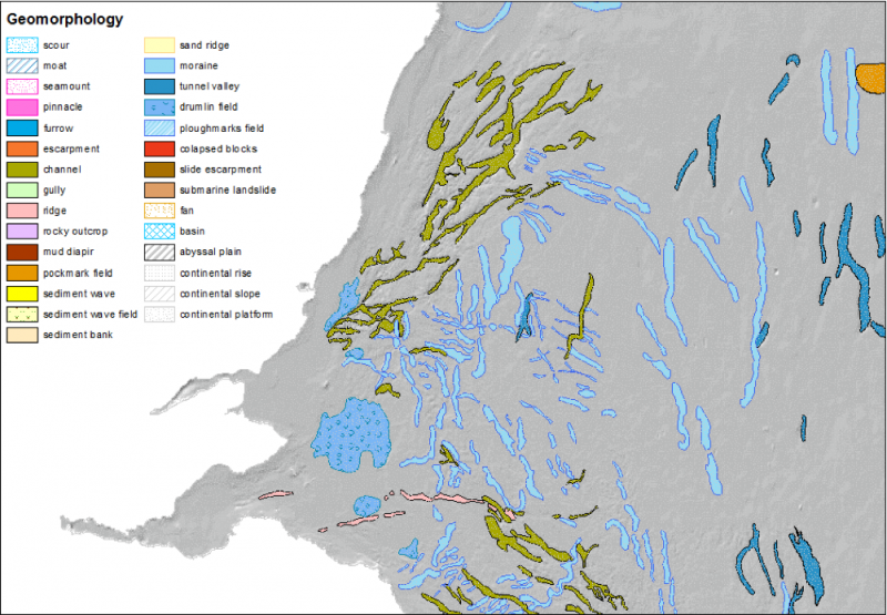
EMODnet Bathymetry data are used by most EMODnet Geology partners to describe and analyse the seabed. Coupled to data products on Seabed Substrate and Lithostratigraphy, geomorphology is being mapped both transnationally and at large spatial scales.
Changes in coastal sea level caused by the combined effect of surface winds and air pressure have the potential to cause widespread coastal flooding, damage to infrastructure and loss of life.
The low-lying lands bordering the North Sea are particularly vulnerable as was seen most notably in the catastrophic events of 1953. It is expected that climate change will increase the frequency and severity of such events.