To understand the full benefits of EMODnet, users are kindly asked to describe how EMODnet supports them in their daily work and activities.
If you have developed an application using EMODnet products that you would like to share with us or if you use EMODnet data for other purposes, submit your use case by contacting secretariat@emodnet.ec.europa.eu.
EMODnet Seabed Habitats data enabled the mapping of potential disturbance to benthic habitats due to fishing in the north-east Atlantic. The assessment was part of the wider OSPAR Intermediate Assessment 2017, which evaluates the status of the marine environment of the North-East Atlantic.
Orsted Power (UK) Ltd are responsible for the development, construction and operation of offshore windfarms across Europe. Hornsea Project Three has been proposed in the North Sea, off the North Norfolk Coast, with the potential to be generating up to 2,400 MW of electricity, the average daily needs of approximately 2 million UK homes.
The pan-European map presenting the distribution of modelled broad scale seabed habitats (EUSeaMap v2016) made available through the EMODnet Seabed Habitats project, was crucial in the assessment recently performed by ISPRA in collaboration with the European Environment Agency to compile information on the distribution of all marine broad-scale habitats for the whole Western Mediterranean basin.
NIVA Denmarkis a regional office under the Norwegian Institute for Water Research (NIVA), an institution with over 50 years experience in applied aquatic science. NIVA Denmark is focussed on applied research in aquatic ecosystems and evidence-based consultancy. Their key areas of research include eutrophication, hazardous substances, biodiversity and ecosystem health, as well as the implications of multiple human activities in aquatic environments.
The development of EMODnet standard classifications for the various categories of seabed substrate allowed a digital map layer covering Russian, Finnish and Estonian waters to contribute towards the Gulf of Finland assessment published in 2016. This was one of the most important outcomes of the Gulf of Finland Year arranged by the three countries in 2014.
Now the approach would be to use ICES and EMODnet Chemistry to provide a comprehensive European data source for the European Environment Agency Marine Indicators on contaminants (Biota) and Eutrophication (Chla, Nutrients) and a pipeline on oxygen saturation.
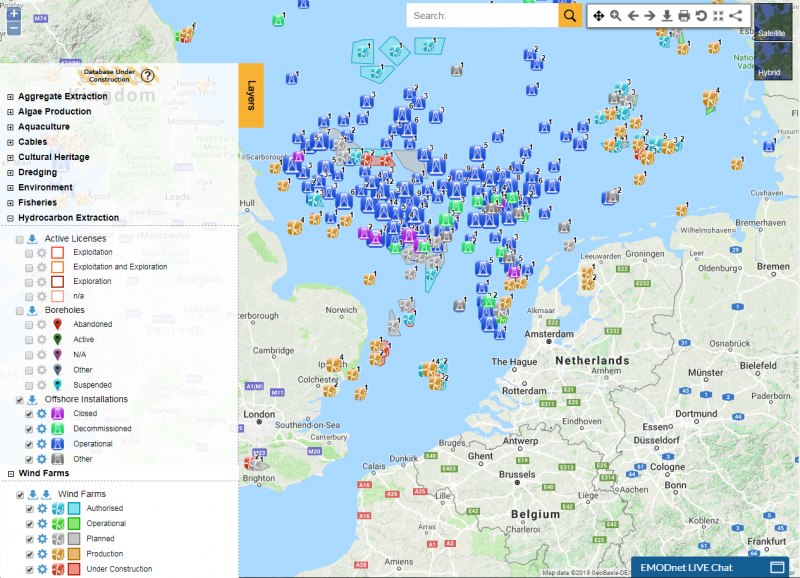
The EMODnet Human Activities portal has become a vital tool for C2Wind, a Danish company working in the wind industry. Wind farm and hydrocarbon extraction datasets are the most commonly explored datasets, identifying locations of already existing structures. Additional datasets on occasion are surveyed to provide the full extent of human activities. This crucial information is used in the preliminary phases of projects, determining areas of interest for the development of wind farm projects.
The University of Ghana deployed a wave rider buoy near the Cape Verde islands for collection of in-situ data on ocean parameters such as wave height and sea surface temperature for validation purposes. In order to make this data available to the global scientific community, collaboration was established with EMODnet Physics to host this data on their distribution platform. The impact of this collaboration has been tremendous, as the data is made easily accessible to both African and European partner institutions, as well as other users.
In a recent research paper (Effrosynidis et al., 2018), the Democritus University of Thrace (DUTH) aggregated CMEMS and EMODnet data to investigate the influence of environmental conditions on the presence-absence and the distribution of seagrass species over the Mediterranean Sea
Symphony is a tool used by the Swedish Agency for Marine and Water Management (SwAM) to assess the cumulative impact of human activity in Swedish waters. In this operation, EMODnet Geology and the Bathymetry portals provided with good knowledge of the distribution of geological substrate types.