European Marine Observation and Data Network (EMODnet)
Use Cases
Submit your Use Case
To understand the full benefits of EMODnet, users are kindly asked to describe how EMODnet supports them in their daily work and activities.
If you have developed an application using EMODnet products that you would like to share with us or if you use EMODnet data for other purposes, submit your use case by contacting helpdesk@emodnet.ec.europa.eu.
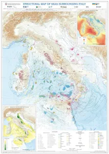
Using EMODnet Geology data, the Department for the Geological Survey of Italy (ISPRA) characterised the structural settings of the seas surrounding Italy. The EMODnet data, particularly from the "Geological events and probabilities" work package, provided insights into tectonic activity, including earthquakes, volcanoes, and submarine landslides. The EMODnet Bathymetry Digital Terrain Model (DTM) helped outline submarine volcanoes, while seabed rock data from the "Seafloor geology" work package aided in understanding geological strata. This comprehensive information allows for the identification of various marine geological settings, forming a solid basis for future studies on marine geohazard assessment, land management, and applied geology.
The Portuguese Institute for Sea and Atmosphere (IPMA), one of the EMODnet partners, is a state laboratory whose mission is to promote and coordinate scientific research, technological development, innovation and services on sea and atmosphere. IPMA is responsible for executing the geophysical, geological, geotechnical and environmental studies in the REPowereu project, which has the aim of developing up to 10 GW of electrical production centers in the offshore of Portugal, based on oceanic renewable energy until 2030.
The University of Southampton and its Southampton Marine and Maritime Institute is a major European centre for oceanography and marine geoscience. The Southampton Marine and Maritime Institute (SMMI) is the largest entity of its kind in the world, with expertise in everything from naval architecture to social sciences and work to address issues in the natural ocean environment (marine) and human use of the sea (maritime).
The University of Aegean is a partner in the MUSICA (Multiple Use of Space for Island Clean Autonomy) project, that developed a smart multi-usage of space (MUS) platform for the concurrent use of three types of renewable energy – wind, photovoltaic and wave – at small islands. The MUS also contributed to the advancement of a successfully tested multi-use platform (MUP), which was previously developed by the University of Aegean and the private company EcoWindWater. In the process of finding optimal siting areas for the MUP, MUSICA used EMODnet map services and data to highlight areas of potential constraints.
Croatian Geological Survey used EMODnet Geology, Bathymetry and Seabed Habitats data to develop the seabed substrate and geology maps within a project that aims to map the marine habitats of the coastal area of the Adriatic Sea up to a depth of 40 m and up to 200 m in protected areas.
Biosfera XXI has been using EMODnet data since 2016, mainly for its marine projects, in particular, the environmental impact assessment project “The electricity interconnection across the Biscay Gulf".
In a recent research paper (Effrosynidis et al., 2018), the Democritus University of Thrace (DUTH) aggregated CMEMS and EMODnet data to investigate the influence of environmental conditions on the presence-absence and the distribution of seagrass species over the Mediterranean Sea
The availability of both depth data and geology data from one centralised point of contact (EMODnet) enabled Irwin Carr Consulting, an SME that provides specialist services that range from environmental noise, air quality, building acoustics and underwater noise, to be competitive and have efficient turn-around times on marine projects that otherwise would be delayed by prohibitively costly marine mapping work prior to impact assessments.
Symphony is a tool used by the Swedish Agency for Marine and Water Management (SwAM) to assess the cumulative impact of human activity in Swedish waters. In this operation, EMODnet Geology and the Bathymetry portals provided with good knowledge of the distribution of geological substrate types.


 Ozren Hasan; b) Slobodan Miko, c), d), e) Ozren Hasan, f) Ante Žuljević")
 and the relation to the seabed substrates (EMODnet Geology).")