European Marine Observation and Data Network (EMODnet)
Use Cases
Submit your Use Case
To understand the full benefits of EMODnet, users are kindly asked to describe how EMODnet supports them in their daily work and activities.
If you have developed an application using EMODnet products that you would like to share with us or if you use EMODnet data for other purposes, submit your use case by contacting helpdesk@emodnet.ec.europa.eu.
Wageningen Marine Research Institute is a part of the wider Wageningen University and Research centre. The marine institute conducts independent scientific research and provides contributions and advice on marine monitoring, spatial planning, sustainable marine exploitation, fisheries and nature-based solutions to climate change. They aim to work towards the more sustainable and careful management, use and protection of marine, coastal and freshwater environments.
NIVA Denmarkis a regional office under the Norwegian Institute for Water Research (NIVA), an institution with over 50 years experience in applied aquatic science. NIVA Denmark is focussed on applied research in aquatic ecosystems and evidence-based consultancy. Their key areas of research include eutrophication, hazardous substances, biodiversity and ecosystem health, as well as the implications of multiple human activities in aquatic environments.
The ADRIPLAN project (10 December 2013 until 10 June 2015) was funded by the European Commission and worked towards an ADRiatic-Ionian maritime spatial PLANning (ADRIPLAN). The project focused on improving the ongoing process to develop Maritime Spatial Planning (MSP) in the region to overcome barriers of full participation of all neighbouring countries in the process.
The Joint Research Centre (JRC) is responsible for creating, managing and making sense of knowledge to support European policies with independent evidence. This includes developing innovative tools and making them available to policy makers, anticipating emerging issues that will need addressed at EU level, understanding policy environments and sharing knowledge with EU countries, the scientific community and international partners.
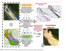
The conservation or the achievement of the Good Environmental Status (GES) is a priority for any environmental policy mechanism of both EU and non-EU countries. Coherent data management and quality control are fundamental whenever data from different sources are required as in the case of the assessment of environmental status at regional or sub-regional scale sensu Marine Strategy Framework Directive (MSFD).
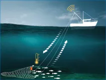
Berring Data Collective (BDC) is a start-up dedicated to ocean observation via collaboration with fishing vessels. Fishing gears such as nets and traps make an ideal platform for compact IoT sensors. When the gears are let down to the bottom and pulled back up with fish, sensors that are along for the ride collect water column profile data. When the net surface data is automatically sent onto ocean data users in near real time.
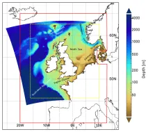
The Met Office provides forecasts of the ocean properties for the European North West Shelf through the Copernicus - Marine Environment Monitoring Service. In 2018, the forecast resolution was upgraded from ~7 to ~1.5 km. Validation at the basin scale and using typical metrics with daily means penalises the high-resolution system and does not reflect the superior performance of the high-resolution system. High resolution observations in selected areas of the model domain were crucial to demonstrate the improvement of the finer resolution model.
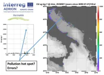
In order to promote a harmonized approach to the evaluation of quality of data of contaminants in the ADRION region, a subset of EMODnet Chemistry data were analyzed to identify measurement units used by the different laboratories, matrix characteristics, concentration ranges as well as completeness of required metadata. According to the results, a common protocol and statistical approach to assess Quality Control of data of contaminants in the marine environment will be proposed and shared within HarmoNIA as well as within EMODnet Chemistry partnerships to improve data quality and fitness for use.
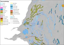
EMODnet Bathymetry data are used by most EMODnet Geology partners to describe and analyse the seabed. Coupled to data products on Seabed Substrate and Lithostratigraphy, geomorphology is being mapped both transnationally and at large spatial scales.
In a recent research paper (Effrosynidis et al., 2018), the Democritus University of Thrace (DUTH) aggregated CMEMS and EMODnet data to investigate the influence of environmental conditions on the presence-absence and the distribution of seagrass species over the Mediterranean Sea