European Marine Observation and Data Network (EMODnet)
Use Cases
Submit your Use Case
To understand the full benefits of EMODnet, users are kindly asked to describe how EMODnet supports them in their daily work and activities.
If you have developed an application using EMODnet products that you would like to share with us or if you use EMODnet data for other purposes, submit your use case by contacting helpdesk@emodnet.ec.europa.eu.
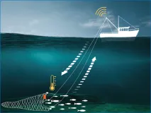
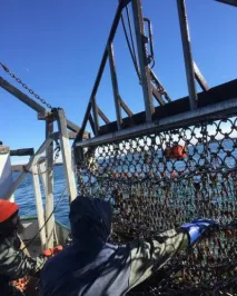
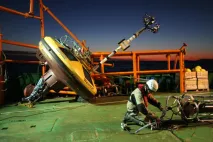
Berring Data Collective (BDC) is a start-up dedicated to ocean observation via collaboration with fishing vessels. Fishing gears such as nets and traps make an ideal platform for compact IoT sensors. When the gears are let down to the bottom and pulled back up with fish, sensors that are along for the ride collect water column profile data. When the net surface data is automatically sent onto ocean data users in near real time.
Despite fishes’ well documented strong sensitivity to temperature and other physical ocean parameters, modelling these shifts has proven difficult. A key issue is the scarcity of temperature data at depth, where fish usually are. As stated by Captain Lawrence Moffet, F/V Matt & Patt:
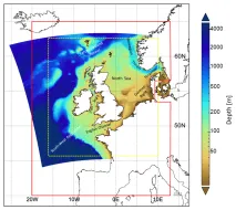
The Met Office provides forecasts of the ocean properties for the European North West Shelf through the Copernicus - Marine Environment Monitoring Service. In 2018, the forecast resolution was upgraded from ~7 to ~1.5 km. Validation at the basin scale and using typical metrics with daily means penalises the high-resolution system and does not reflect the superior performance of the high-resolution system. High resolution observations in selected areas of the model domain were crucial to demonstrate the improvement of the finer resolution model.
SINDBAD+, is a project co-funded by the European Commission (POR FESR 2014-2020), that aims at providing a service that can predict weather conditions and analyse its consequences on the navigation depending on the characteristics of the boat such as length, width and depth. The service targets luxury and leisure boaters. The SINDBAD partners use EMODnet Physics and EMODnet Bathymetry to initiate and validate data forecast models.
EMODnet Physics has developed a user-friendly interface for the Copernicus Marine Environment Monitoring Service (CMEMS) In Situ Thematic Assembly Centre to improve the viewing service developed for outreach and promotion activities.
The EMODnet Physics Portal map viewer allows the Fisheries and Oceans department of the Government of Canada to quickly view where a platform is located and which platforms are located next to it.
Leveraging on the EMODnet radar data, PM_TEN, an Italian, technology-transfer company active in the Environmental Physics field, has released a new service for its customers (as part of an environmental impact assessment package) which uses EMODnet radar data to integrate the output of numerical circulation models and provide a solid and validated input to oil spill models.
The EMODnet River data service provided by EMODnet Physics will support the LAMBDA (LAnd-Marine Boundary Development and Analysis) project to demonstrate the quality of modelling results produced by the watershed models. The EMODnet river service will enhance the Copernicus Marine Environment Monitoring Service (CMEMS) by aiding in watershed models validation and quality control thus improving their forecast services.
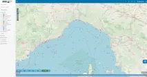
The challenge of the EuskOOS operational oceanography system of the Basque coast is to disseminate the marine data collected from the Basque Country making them part of global efforts. Instead of building the system from scratch, EuskOOS decided to reuse the widget made available by EMODnet Physics such as the data products and the map sharing service to build its regional operational oceanography system. EuskOOS is also now one of the EMODnet contributors, providing data of the coastal observing system into the European Marine Observation and Data Network.
The University of Ghana deployed a wave rider buoy near the Cape Verde islands for collection of in-situ data on ocean parameters such as wave height and sea surface temperature for validation purposes. In order to make this data available to the global scientific community, collaboration was established with EMODnet Physics to host this data on their distribution platform. The impact of this collaboration has been tremendous, as the data is made easily accessible to both African and European partner institutions, as well as other users.