European Marine Observation and Data Network (EMODnet)
Use Cases
Submit your Use Case
To understand the full benefits of EMODnet, users are kindly asked to describe how EMODnet supports them in their daily work and activities.
If you have developed an application using EMODnet products that you would like to share with us or if you use EMODnet data for other purposes, submit your use case by contacting helpdesk@emodnet.ec.europa.eu.
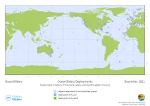
One of the main goals of OceanGliders, as part of GOOS, is to monitor and promote the activity of the glider observing network. The goal is not to provide data, but to document and give guidance on how to share someone’s glider activity, in order to raise their visibility and the visibility of gliders as whole, as concerns long-term sustained observing for societal benefit.
CSCS carries out glider missions all over the world. Gliders are small autonomous underwater vehicles that use changes in displacement to change buoyancy, and internal mass movements to attain pitch and roll movements. Coordinated by an on-board flight computer, this slow but very efficient profiling device collects data as it descends and ascends, sending the results and receiving commands every few hours when at the surface for many months at a time.
The Euro-Mediterranean Center on Climate Change (CMCC) has developed a first version of a web application with the “Total Sea Level” variable from EMODnet Physics. This solution presents a demonstrator of end-user application and decisional support dashboard systems to support public authorities in their daily management activities.
Collaboration between EMODnet Biology, EMODnet Seabed Habitats and OBIS (Ocean Biodiversity Information System) has facilitated richer dataset publication and ensured the greatest volume of high-quality species and habitat data are available for reporting, assessments and informed decision making.
Outcomes:Researchers were able to model the suitable habitat for European hake, Merluccius merluccius, in their first year of life (0-group) in the Mediterranean Sea. The results show that hake nurseries require stable bottom temperatures, low bottom currents and a frequent occurrence of productive fronts in low chlorophyll-a areas in order to support successful recruitment, with conditions occurring recurrently in outer shelf and shelf break areas. This prediction explains the role of unfavourable environmental conditions on low recruitment in past years.<
Outcomes:Based on the study of morphological species diversity and distribution, authors were able to re-defined the circalittoral zone in the Azores islands.
How EMODnet Seabed Habitats helped the user:EMODnet provided the best data source to represent marine benthic habitats in the Azores.
Outcomes:Authors used an Ecological Niche Model to identify previously overlooked areas of the Mediterranean and Eastern Atlantic, as areas containing soft coral habitats. The model could then be used for future surveys to target areas predicting presence of coral habitats and identify new priority conservation areas.
How EMODnet Seabed Habitats helped the user:EUSeaMap provided information on the distribution of rocky bottomed habitats across the study area.
Outcomes:. Authors were able to identify that differences in diet of grey seals (Halichoerus grypus) reflect regional differences in physical habitat features.
How EMODnet Seabed Habitats helped the user:Sediment and depth data were derived utilising output of the EUSeaMap 2016.
Outcomes:Assessors highlighted environmental covariates with the greatest influence on porpoise density distribution models. Resulting distribution maps were then used to propose areas suitable for protection of these marine mammals in Swedish waters.
How EMODnet Seabed Habitats helped the user:EUSeaMap provided some of the data used in the habitat distribution models
Outcomes: Authors were able to quantify the effects of the invasive polychaete Marenzelleria spp on sediment nutrient cycling in the Baltic Sea. The results identified that an overall reduction in the self-cleaning capacity of the basin would create a higher cost to stakeholders to meet international commitments such as the HELCOM Baltic Sea Action Plan and the Marine Strategy Framework Directive.