European Marine Observation and Data Network (EMODnet)
Use Cases
Submit your Use Case
To understand the full benefits of EMODnet, users are kindly asked to describe how EMODnet supports them in their daily work and activities.
If you have developed an application using EMODnet products that you would like to share with us or if you use EMODnet data for other purposes, submit your use case by contacting helpdesk@emodnet.ec.europa.eu.
SINDBAD+, is a project co-funded by the European Commission (POR FESR 2014-2020), that aims at providing a service that can predict weather conditions and analyse its consequences on the navigation depending on the characteristics of the boat such as length, width and depth. The service targets luxury and leisure boaters. The SINDBAD partners use EMODnet Physics and EMODnet Bathymetry to initiate and validate data forecast models.
The EMODnet Human Activities portal has become a vital tool for C2Wind, a Danish company working in the wind industry. Wind farm and hydrocarbon extraction datasets are the most commonly explored datasets, identifying locations of already existing structures. Additional datasets on occasion are surveyed to provide the full extent of human activities. This crucial information is used in the preliminary phases of projects, determining areas of interest for the development of wind farm projects.
The European contribution to the Ocean Biogeographic Information System (OBIS) is significant with EMODnet playing a pivotal role: around 20 million of these records are provided by EMODnet Biology.
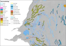
EMODnet Bathymetry data are used by most EMODnet Geology partners to describe and analyse the seabed. Coupled to data products on Seabed Substrate and Lithostratigraphy, geomorphology is being mapped both transnationally and at large spatial scales.
With continued development of portals and a promise to remain an open source of data, EMODnet enables its clients to become more efficient, provide better services and remain competitive in the market.
Biosfera XXI has been using EMODnet data since 2016, mainly for its marine projects, in particular, the environmental impact assessment project “The electricity interconnection across the Biscay Gulf".
In a recent research paper (Effrosynidis et al., 2018), the Democritus University of Thrace (DUTH) aggregated CMEMS and EMODnet data to investigate the influence of environmental conditions on the presence-absence and the distribution of seagrass species over the Mediterranean Sea
Undertaking a regional cumulative impact assessment requires a vast amount of spatial data. EUSeaMap v2016 was a key data source for defining ecosystem components in reporting on the 2011-2016 HELCOM ‘State of the Baltic Sea’.
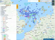
EMODnet Physics has developed a user-friendly interface for the Copernicus Marine Environment Monitoring Service (CMEMS) In Situ Thematic Assembly Centre to improve the viewing service developed for outreach and promotion activities.
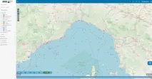
The EMODnet Physics Portal map viewer allows the Fisheries and Oceans department of the Government of Canada to quickly view where a platform is located and which platforms are located next to it.